World
Severe Weather Alert: Heavy Rain and Strong Winds Hit South West
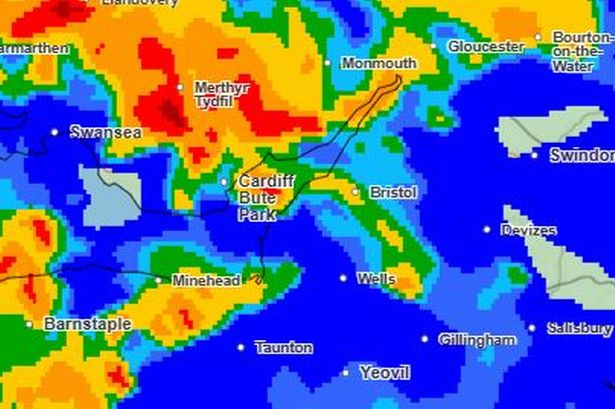
A severe weather warning has been issued for the South West of England, with the Met Office forecasting strong winds and heavy rain that could lead to travel disruptions and power outages. The yellow alert is set to take effect from 20:00 on Sunday, September 14, 2023, lasting until 18:00 on Monday, September 15, 2023.
Heavy rainfall is expected to begin in Gloucestershire around 14:00 on Sunday, continuing until 18:00 the same day. Wind gusts in the region could reach up to 34 mph, escalating to 48 mph by Monday afternoon. In Bristol, heavy rain is anticipated to start at 13:00 and persist until 19:00, with wind gusts of 36 mph on Sunday, increasing to 50 mph on Monday.
Somerset will also experience significant rainfall, particularly from noon to 14:00 and again from 17:00 to 18:00. Wind gusts in Somerset are projected to reach 36 mph on Sunday and 48 mph the following day.
Forecast Details and Impact
In its latest update, the Met Office noted that a low-pressure system moving in on Sunday would “squeeze the isobars together,” resulting in increasingly windy conditions. Strong winds are expected to persist into Monday, bringing the possibility of severe gales along exposed coastal areas and leading to potential travel disruptions.
Stephen Kocher, Deputy Chief Meteorologist at the Met Office, explained, “Strong west or southwesterly winds will arrive across coastal areas of southwest England and Wales during Sunday evening, spreading inland and eastwards during Monday morning. Gusts of 45-55 mph are expected widely in inland areas, while gusts of 60-70 mph are possible at times along exposed coasts and hills.”
The warning highlights that strong and gusty winds may disrupt travel and lead to power interruptions.
This evening, there may be some late sunshine as conditions briefly settle overnight, with winds easing and showers gradually fading. However, it will feel cooler than previous nights, especially in rural areas, with a minimum temperature of 6 °C.
Looking ahead to Sunday, a band of rain will move northeast throughout the day, bringing heavy downpours and strong winds. Maximum temperatures are expected to reach 18 °C, contributing to a muggy atmosphere.
What to Expect Next Week
The outlook for Monday through Wednesday indicates that strong winds and blustery showers will continue, with winds easing and showers subsiding overnight. Tuesday is forecast to bring a brighter and drier day, but conditions will turn wet and windy again on Wednesday.
Residents in affected areas are advised to prepare for potential disruptions and keep updated with the latest weather forecasts.

Niksic Celebrates Cultural Legacy with Folklore Milestone

NLC Demands Urgent Wage Adjustments Amid Rising Living Costs

‘One Battle After Another’ Triumphs with Six Oscars at 98th Academy Awards
Rainy Monday in Alton Clears for Sunshine by Midweek

Residents Push for New Supermarket in Overcrowded Town

Jimmy Kimmel Critiques Trump at 98th Academy Awards Ceremony

Young People Face Job Market Challenges Due to Health Issues

Stars Shine at the 2026 Oscars: Adorable Couples Take Center Stage

Brooklyn Beckham Faces Backlash for Mother’s Day Message Snub

Andrew Pierce Confirms Departure from ITV’s Good Morning Britain

Coronation Street Reveals Audrey Roberts’ Absence Explained

Fiona Phillips’ Husband Shares Heartfelt Update on Her Alzheimer’s Journey

Gogglebox Star Helena Worthington Announces Break After Loss

Neurologist Warns Excessive Use of Supplements Can Harm Brain

Brian Cox Addresses Claims of Alien Probe in 3I/ATLAS Discovery

NASA Investigates Unusual Comet 3I/ATLAS; New Findings Emerge

EastEnders Welcomes Back Mark Fowler Jr. with New Actor

Tess Daly Honoured with MBE, Announces Departure from Strictly
-
 Entertainment6 months ago
Andrew Pierce Confirms Departure from ITV’s Good Morning Britain
-
 Entertainment3 months ago
Coronation Street Reveals Audrey Roberts’ Absence Explained
-
 Health9 months ago
Fiona Phillips’ Husband Shares Heartfelt Update on Her Alzheimer’s Journey
-
 Entertainment5 months ago
Gogglebox Star Helena Worthington Announces Break After Loss
-
 Health9 months ago
Neurologist Warns Excessive Use of Supplements Can Harm Brain
-
 Science7 months ago
Brian Cox Addresses Claims of Alien Probe in 3I/ATLAS Discovery
-
 Science7 months ago
NASA Investigates Unusual Comet 3I/ATLAS; New Findings Emerge
-
 World4 months ago
EastEnders Welcomes Back Mark Fowler Jr. with New Actor
-
 Entertainment6 months ago
Tess Daly Honoured with MBE, Announces Departure from Strictly
-

 Health4 months ago
Gyles Brandreth Shares Heartfelt Journey Following Grandson’s Cancer Diagnosis
-

 Entertainment9 months ago
Major Cast Changes at Coronation Street: Exits and Returns in 2025
-

 World7 months ago
EastEnders’ Nicola Mitchell Faces Life-Changing Pregnancy Twist